The Parang La trek is an age-old trade route that links the regions of Spiti in Himachal, Tibet, and Changthang in Ladakh. This trek can be initiated from either Karzok village in Leh or from Chicham/Kibber village in Spiti. The trail reaches its highest point at Parang La, which stands at an altitude of approximately 5600 meters. It follows the Pare Chu river, which enters Tibet and then returns to India. One of the main attractions of this route is its ancient yet dynamic mountain formations, which bear a striking resemblance to having been submerged under the sea for an extended period. These formations are home to various unique fossils. Moreover, the path encompasses expansive meadows that have traditionally served as grazing areas for horses from the Spiti Valley. One of the most awe-inspiring segments of the trek involves a two-day walk alongside the enchanting Tso Moriri Lake. This lake exhibits a mesmerizing range of blue shades against a backdrop of numerous unconquered peaks. The journey concludes at Karzok village, which is the location of one of the oldest and most influential monasteries in Leh.
On the first day, you will travel from Manali to Kaza, covering a distance of 202 kilometers. It is advisable to arrive in Manali a day prior to adequately prepare for the upcoming days in a remote area. This day can be utilized for finalizing your packing list and purchasing any necessary items, as Manali is the last major town where all essential items are available. Spending a night in Manali also helps with acclimatization. Beginning early in the day, you will pass through Rohtang Pass and Kunzum La, which houses the famous Kunzum Mata Mandir. The drive from Kunzum La to Kaza offers beautiful scenery, with the Spiti River flowing alongside and the Key Monastery in the background. Arriving in Kaza early allows you to explore the local market, which is usually bustling with tourists from June to late October. Overnight accommodation will be provided in a hotel in Kaza.
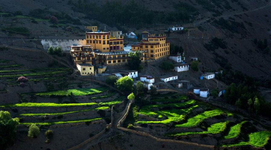
The second day is dedicated to resting and acclimatizing in Chicham. In the morning, you will start with a short hill walk. The day is designed to keep you physically active, including a walk along the Spiti River bank after breakfast and a visit to the local Key monasteries and gompa in the afternoon. After exploring the monastery, you will head towards Chicham village, crossing its famous trolley bridge. Overnight stay will be arranged in a homestay in Chicham, which is the starting point of the trek and situated at an altitude of 4270 meters.
The third day is another opportunity for rest and acclimatization in Chicham.
The trek commences from Chicham on a well-paved metallic road, gradually leading you out of the village. After approximately 45 minutes of walking, you will reach the Dumla campsite located in the valley below. Dumla campsite serves as an ideal resting point for those starting their trek from Kibber. From Dumla, there is a steep ascent for about 3 hours, offering views of typical Spiti mountains and featuring loose soil and gravel trails with Thama vegetation. This ascent is followed by a zig-zag dusty flat trail, revealing more mountain ranges. As you approach Thaltak, the Kanamo peak becomes visible on the right side, surrounded by barren mountains. It takes around 6-6.6 hours to reach the Thaltak campsite, which is an oasis in the middle of the barren land and offers a stunning view of the Kanamo Peak. Overnight accommodation will be provided in camps.
The trail from Thaltak descends into a deep gorge with loose rocks and gravel, requiring caution while descending due to the prominent rockfall zone. The trail continues along the upstream of the Rong Nala river, crossing the Rong Nala bridge. From there, the ascent to Jukhta begins, gradually ascending with open views of the eroding mountain faces of Spiti valley. The climb leads to Borochen, the campsite for the day, situated at the foot of Parang La and devoid of vegetation. The trek covers a distance of 12 kilometers and takes nearly 8 hours, with an ascent of 857 meters and a descent of 455 meters.
Day 6 is the pass day of the trek, which is demanding, especially at an altitude of 5100 meters. After a steep climb through moraines, you will reach the Thakchu campsite. The climb towards the pass continues along a zig-zag trail marked by mule and horse tracks. It takes 3.5 to 5 hours to reach the highest point of the Parang La trek, offering great views of the Spiti and Changthang valleys, as well as the Parilungi peak. After crossing the pass, the trail descends on the Parang La glacier. Caution must be exercised while navigating the glacier due to its crevasses. After approximately 2 hours of descent, you will reach the Lakku campsite. Following the downstream path of the glacier river, you will arrive at the Kharsa Yongma campsite, which takes around 1.5 hours. The day involves an ascent of 548 meters and a descent of 750 meters.
The trail follows the downstream course of the Datang Nala river, crossing various streams and campsites along the vast riverbed. The Racholamo campsite is located at the intersection of two valleys after Falangbado Nala joins the main river. The trail continues on the riverbed, with several river streams and tributaries merging into the main Pare Chu river. The day covers a distance of 20 kilometers, with an ascent of 290 meters and a descent of 396 meters.
Similar to the previous day, the trail from Kapapuche to Kitpodansa mostly follows the riverbed of the Pare River. Several river streams and tributaries join the main river along the way, including Falangbado Nala and Lakuk Nala. The trail remains on the riverbed throughout the day.
The trail takes a sudden left turn towards Norbu Sumdo after following the downstream course of the Parechu River. The major challenge or attraction of the day is crossing the strong current of the Parechu River, which requires forming a human chain to cross. After crossing the river, the landscape changes from a barren riverbed to lush green meadows with small yellow flowers and streams. This is Norbu Sumdo, the gateway to Ladakh and the border between Spiti and Ladakh. After an hour of walking, you will reach the Chumik Shilde campsite, surrounded by lush green meadows and abundant spring water.
The trail ahead is flat land with meadows, and you can catch glimpses of snow-covered peaks in the Mentok series. As you progress, you will start seeing the pristine Tso Moriri Lake. There is no water source between Chumik Shilde and Kiangdom, but the campsite is known for its wild asses. The day involves an ascent of 121 meters and a descent of 76 meters.
During the eleventh day of the trek, you will follow the shoreline of Tsomoriri lake, always keeping the lake on your right side. This particular route offers breathtaking views of Chamsher Kangri peak and Lungser Kangri peak in the background. The final ascent to Korzok village comes after several days of trekking. The journey covers a distance of 21.5 kilometers, taking approximately 8 hours and 22 minutes. The ascent for the day is 226 meters, with a descent of 179 meters
On the twelfth day, in the morning, you will board a shared vehicle for a 240-kilometer drive from Karzok to Leh. The estimated travel time to reach Leh is around 5-6 hours. If necessary, you can request our representatives to arrange transportation from Karzok to Leh and assist with additional accommodation in Leh. Please be aware that these arrangements may involve an additional fee.